25 April 1604. A huge fleet of 800 ships set sail from the Rede van Vlissingen to the Island of Cadzand. On board: 11,000 soldiers led by Prince Maurits. Goal: liberate Oostende from a Spanish siege which had lasted nearly three years. The harbour town was the last bulwark of the States in Flanders (together with the towns of Biervliet, Terneuzen and Axel). For them, it was an important bridgehead from where they could make life very difficult for the Spaniards.
Very quickly, the States conquered the island. However, they did not manage to cross the Zwin and decided to approach Oostende another way. The Spanish forts near Oostburg, IJzendijke and the stronghold of Aardenburg were captured one by one. Maurits then turned his weapons on Sluis, the base of Spanish galleys, which seriously hindered supplies to Oostende by sea.
In order to close the Zwin, the States circumvented Sluis and occupied the western bank of the Zwin… the siege of Sluis began.
Maurits had an impenetrable chain of defence works erected around Sluis (a so-called circumvallation line). The Spanish troops in the town could go nowhere. Starvation and infectious diseases threatened the town’s population as well as the 3000 to 4000 soldiers and over 1400 galley slaves garrisoned there.
After two months, the Spanish general Spinola arrived with a relief force, but that operation ended in a bloody fiasco. Sluis was lost to Spain. After three months, the Spanish occupation surrendered.
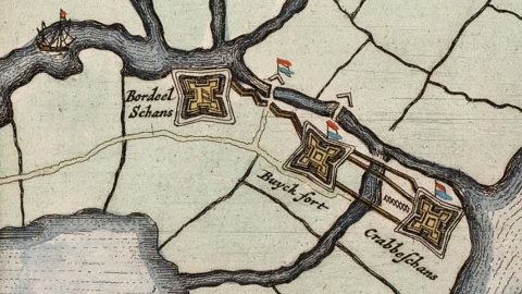
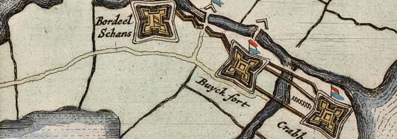
In the circumvallation line around Sluis, there were 13 redoubts. These were small square forts, with a bastion on each corner and surrounded by a moat. One of these was the Bordeelschans.
On the map of J. Blaeu (1649), which shows the siege of Sluis, we can see that the Bordeelschans was linked by a zigzag dyke with the Buyckfort. Together with the Krabbeschans, the forts were situated on the northern bank of a stream, which was part of an extensive system in the flooded area to the east, south and southwest of Sluis.
Some redoubts were restored or extended after the capture of Sluis (like the Krabbeschans) and retained their military function. The Bordeelschans was probably not restored again. A map dating from 1622 shows that the redoubt was demolished.
In 2012, the Bordeelschans was partially reconstructed in the framework of Interreg IV-A project “Forts and Lines in Border-Wide Perspective”.
The word bordeel comes from the Middle Dutch “bordel” (1276-1350), meaning “hut or hovel” and “house of ill repute”. “Bordel” comes from the Old French (12th century) and means exactly the same in that language. It is a diminutive of “borde”, which in Old French means “farmhouse” or “plank hut”. “Borde” comes from the Frankish “borda”: a plank.
The origin of the name of the fort may therefore be less mischievous than it seems.

