In 1583, Alexander Farnese, the later Duke of Parma who had been sent to the Netherlands by the Spanish king to put down the Revolt, invaded Northern Flanders. In response, troops supporting the States led by Filips Count of Hohenlohe quickly took the towns of Terneuzen and Biervliet. They thus acquired a bridgehead in enemy territory. However, Hulst and Sas van Gent were conquered by Farnese.
In order to obstruct his advance, the rebels opened several dykes, flooding the hinterland (inundations). In 1584, this was the sea dyke along the Honte (now Westerschelde) at Campen. Due to the action of ebb and flow, a large stream emerged: the Hellegat. This sea channel separated the Land of Hulst from that of Axel. In 1586, the Braakmandijk between Sas van Gent and Terneuzen was opened. This allowed the Braakman to expand eastwards creating the Axelsche Gat, which ultimately joined the Hellegat. The Land of Axel became an island!
In that same year (1586), the States also took Axel, whereby the entire Land of Axel became (and remained) States territory.
In order to protect itself against attacks by the States from the Land of Axel, the Spaniards built a number of forts on the southern banks of the Axelsche Gat, i.e. (from west to east): Sint-Anthonius, Sint-Steven, Sint-Elooi, Creckeldijck, (near the later Sint-Franciscus), Sint-Marcus and Sint-Anna. These forts formed the start of the later Line of Communication between Sas van Gent and Hulst.
For over forty years, not much happened in this area until Philippine was taken by the States in 1633. They turned this Spanish fort on the southern bank of the Braakman into a stronghold, thus giving the States a new bridgehead in Spanish territory.
The stronghold lay on deep water and was therefore ideal for landing a large army. Due to the threat that this posed, the Spaniards quickly set to strengthening the forts on the southern bank of the Axelsche Gat and built numerous more. The new forts were given a place in the sea dykes of newly reclaimed land, whereby (nearly) all the forts were linked with each other. The Line of Communication was born.
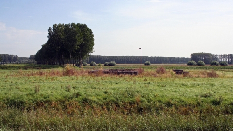
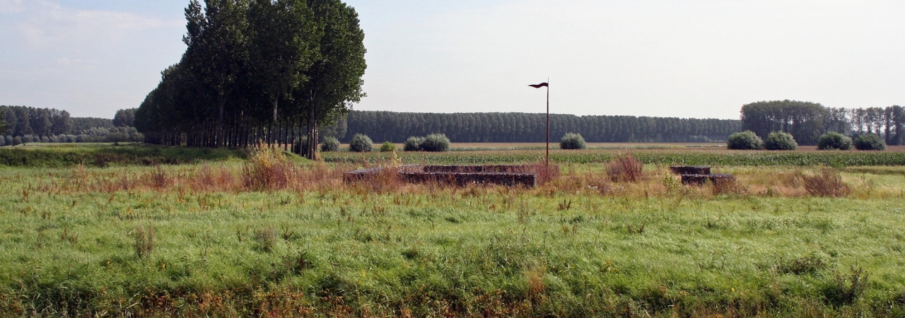
Not much survives of the Spanish forts from the end of the 16th century. With an experienced eye, the remains of Sint-Steven and Sint-Anthonius can still be traced. By contrast, most of the forts from 1634 are reasonably to easily visible, such as (from west to east): Sint-Jan, Sint-Joseph, Sint-Jacob, Sint-Livinus, Sint-Nicolaas and Ferdinandus. These were simple, square works, whose central courtyard was surrounded by a 10 m wide canal. The fort could be accessed via a bridge over the canal. Experts are still not agreed on whether the inner courtyards were walled or not. Thickening of the ground around the inner courtyards could indicate the presence of an embankment. The forts served as watchtowers along the outer dykes of the stream and salt marsh area and therefore had guardhouses, like watchtowers.
After Sas van Gent (1644) and Hulst (1645) were taken by Prince Frederik Hendrik, the Line fell into States’ hands. After this, most of the forts were abandoned. Only Sint-Antonie, Sint-Steven and Sint-Marcus retained a military function for a while. On Sint-Jan, Sint-Nicolaas and Ferdinandus, farms were established.
At the end of the 17th century, a plan was drawn up to create a single water line in a southerly direction between Zwin and Saeftinghe. This plan involved using the many tidal streams and channels and systems were conceived to enable the controlled flooding of certain areas (inundation). The tidal area to the north of the Line of Communication was also incorporated in the water line. On the other side, along the southern coast of the Land of Axel, a new line appeared: the Line of Axel.
As with many other Spanish forts, nearly all the forts in the Line of Communication were named after saints.
The names of States (and thus protestant) forts had a more earthly character and often reflected the hard, tough life of a soldier, with examples like Misère (Misery), Grotendorst (Great Thirst), Scherpbier (Ale), Kaas en Brood (Bread and Cheese), Melk en Brokken (Milk and Hunks), Boerenverdriet (Farmers’ Sadness) and Patiëntie (Patience).
In the Second World War, the former forts proved useful again. On 16 September 1944, Polish soldiers reached the Line from the south east. The advance line of Germans entrenched themselves in Axel and behind the former 18th century line to the east of the town. They had flooded the polders to the south to create an obstacle. Fierce fighting took place over four days and many soldiers were lost. The forts of St.-Joseph, St.-Jacob, St.-Livinus, St.-Nicolaas and Ferdinandus were used by the Poles as a place to hide, regroup and rest. They also set up arms to fire at Axel. On 19 September, the Poles managed to break through the German positions and Axel was liberated.
In 2005-2007, the forts Sint-Joseph, Sint-Jacob and Sint-Livinus were made more visible. A lovely cycle path/footpath on the line dyke links the three forts, which are open to the public. That dyke is almost completely intact from Sint-Anthonius to the Kanaal van Gent to Terneuzen to just beyond Absdale. In 2010, Sint-Jan was refurbished and is easily visible from all sides from the road.

